Working with the resulting solution
If the result in the Planning section used to look different and you'd like to clarify the details of the previous format, see Working with the resulting solution.
Page elements
The page for working with the resulting solution has the following blocks:
- Control panel: General actions.
- Routes: Route metrics and final indicators.
- Orders and Unassigned orders: Orders that were included in the route and orders that couldn't be included.
- Map: A geographical representation of the routes and unassigned orders.
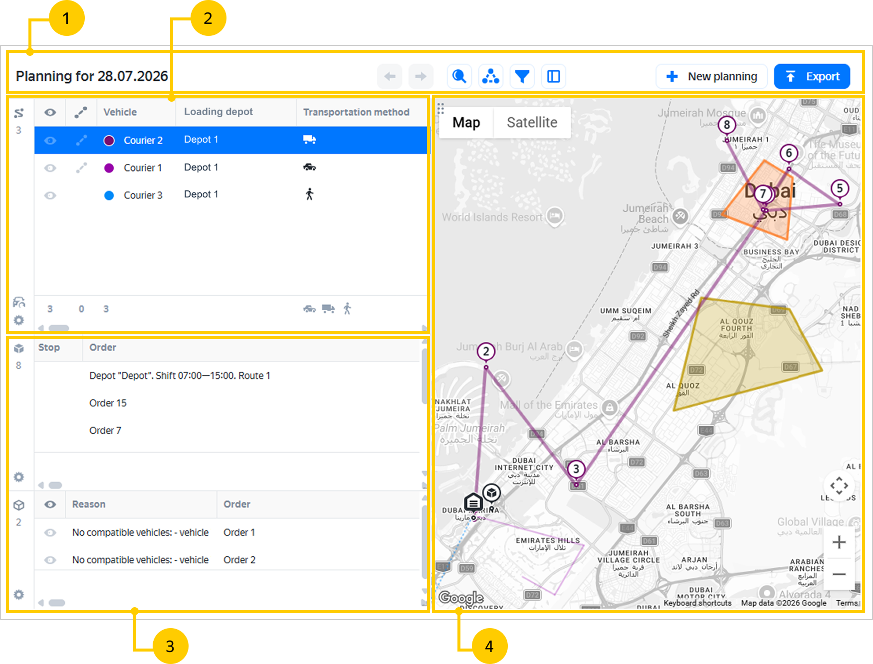
You can change the block layout:
-
Position the block: Hover over the upper-left corner of the block, and left-click and drag the block to the desired location.
-
Adjust the size: Use the control element in the lower-right corner of the block.
-
Change width of columns: To adjust the column width, move the borders of the column header.
-
Reorder columns and choose which ones to show: Click in the lower-left corner of the block. To:
- adjust the column order, drag the column name to the desired position in the list;
- hide a column, disable the option with the relevant name.
To return to the standard settings, click Reset.
Control panel
The control panel displays the following elements:
|
Element |
Name |
Description |
|
Date |
— |
The date that the solution is planned for. |
|
|
Actions with recent changes |
Allow you to undo and redo recent changes. |
|
Search |
Allows you to go to a specific object. To do this, select an order or a route from the drop-down list, and it will be highlighted in the blocks. If you select a depot, the Routes block will show only the routes where the courier visits that depot. |
|
|
Geofences |
Appears if geofences were specified during planning. Allows you to show and hide geofences on the map. If the list is large, use the search bar. To return to the default settings, click Reset. |
|
|
Filter |
Appears if vehicle tags were used during planning. The filter lists the values from the Vehicle properties field in the Routes table (equivalent to tags). To display routes that match specific vehicle properties, select the relevant value. You can select multiple values. As a result, data is filtered across all blocks. |
|
|
Interface view |
Select one of the block layout options. |
The New planning button starts a new planning task. To avoid losing the current solution's results, save the task_id before starting a new planning task.
The Export button is used for exporting solutions.
Routes
The number of planned routes is displayed on the left panel under the icon.
When you hover over a route, the map will display a tooltip with vehicle information and order properties: load by weight, volume, and capacity (cargo units).
In the Routes section, you can see the following icons:
|
Icon |
Description |
Comment |
|
There are comments on the route. |
Hover over the icon to see the comments. |
|
|
Allows you to hide the route on the map. |
If you click it in the table header, all routes will be hidden. |
|
|
Switches the route display to the Yandex Maps service. |
— |
|
|
There's additional information about the route. |
Hover over the icon to see the comments. |
|
|
Switches the route display mode: simple straight lines or roads. |
To enable this feature, contact technical support. |
If a planned route is specified in the task, the icon is displayed in the following cases:
- one of the planned routes was modified — orders were added or removed, or part of the orders was moved to another run. The "Route with changes" comment will be displayed, and the route will be highlighted in yellow;
- a new route was added that wasn't specified in the planned routes. The "New route" icon will be displayed, and the route won't be highlighted in color.
Routes table
The Planning system arranges routes as a table with parameters.
Routes table parameters
- Vehicle
- Transportation method
- Shift
- Run
- Orders
- Stops
- Mileage, km
- Time on route
- Route start time
- Route end time
- Waiting time
- Time window violations
- Load capacity, kg
- Load, kg
- Carried, kg
- Max load on departure from the depot, kg
- Capacity, m³
- Load, m³
- Carried, m³
- Max load on departure from the depot, m³
- Capacity, items
- Custom capacity units
- Load, items
- Carried, items
- Max load on departure from the depot, items
- Trailer weight, kg
- Vehicle properties
- Allowed geofences
- Forbidden geofences
- Courier payments per run
- Courier payments per shift
- Courier payments per route
- Courier payments
- Average time in the vehicle
- Max time in the vehicle
Max load on departure from the depot — parameters that relate to a specific route and reflect the maximum number of kilograms (max_load_on_departure_weight_kg), cubic meters (max_load_on_departure_volume_m3), or items (max_load_on_departure_units) loaded into the vehicle when leaving the starting or intermediate depots. The Planning system doesn't take the final depot indicators into account when determining the maximum load.
Note
The maximum load isn't the sum of the indicators across the route's depots. It's the largest number of kg, m³, and items that you loaded into the vehicle when visiting depots along the way.
For example, a courier starts the route from depot 1, where they pick up the first order. Their load on departure is 100 kg and 0.5 m³. One item is occupied in the vehicle. Next, the courier stops at intermediate depot 2, where they load three more orders with a total weight of 300 kg and a volume of 1.5 m³. They take up three items in the vehicle. As a result, the maximum load on departure from the depot will be:
- Max load on departure from the depot, kg = 300 kg;
- Max load on departure from the depot, m³ = 1.5 m³;
- Max load on departure from the depot, items = 3.
The Planning system rounds the numeric values of the maximum load to two decimal places. You can compare them with the capacity and load values. The load values are also calculated by the system in kg, m³, and the number of items, but they're summed up across the route's depots. For clarity, a visual scale is displayed in the cells of the load and maximum load indicators. If the vehicle is overloaded, it turns red.
To make sure the maximum load values are correctly and fully determined in the routes table, make sure you specified the following parameters in the Planning file:
-
on the Orders sheet:
- Weight, kg (
locations.shipment_size.weight_kgin the Planning API); - Number of items (
locations.shipment_size.units); - Order volume (
locations.shipment_size.volume) or Order volume, m³ (locations.shipment_size.volume_cbm);
- Weight, kg (
-
on the Vehicles sheet:
- Load capacity, kg (
vehicles.capacity.weight_kg); - Capacity, items (
vehicles.capacity.units); - Capacity, m³ (
vehicles.capacity.volume_cbm).
- Load capacity, kg (
The system calculates and displays the maximum load in the interface only if there's enough data.
To see the maximum load values for a specific depot:
-
In the Routes section, select a route.
-
Go to the Orders section and find the row with the depot. The maximum load information will be displayed below it.
Enabling road display mode for a route
To see how your route is plotted along the roads, click in the Routes tab.
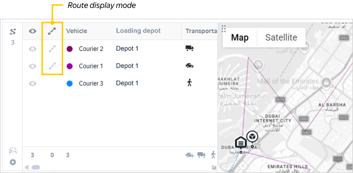
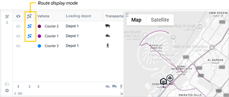
In road display mode, hover over the route point. This will highlight the road segment from the previous point to the current one.
You can also toggle road display mode by exporting your solution. Use this method if you encounter the error "You don't have the rights to view results". To do this:
- Open the desired route in Routing Workspace.
- In the upper-right corner, click Export → JSON.
- Wait for the buttons to activate.
- Select where you want to view the route:
- Click Map.
- The solution opens on
mvrp-map. - Click to toggle road display mode.
- Close the export window.
- Go to Planning → History.
- Open the last Export to system (JSON) solution.
- Click to toggle road display mode.
Transferring a route
If you want to transfer a planned route to another vehicle:
-
Select the route in the list.
-
On the left panel, click .
-
Select another vehicle from the list. Use the search bar if necessary.
-
Click Change vehicle.
The transfer is possible if the following conditions are met:
-
If the depots for the vehicle you want to transfer the route from are specified in the
depot_idfield (with no separation into starting, intermediate, and ending), you can transfer its route:- to a vehicle that already has a route assigned, if only the same depots as the original vehicle are specified for it;
- to a free vehicle, if the original vehicle's depots are specified for it, among others.
-
If the depots to start the route from (
starting_depot_id), intermediate depots (middle_depot_id), and depots to end the route at (ending_depot_id) are specified for the vehicle you want to transfer the route from, you can transfer its route:- to a vehicle that already has a route assigned, if only the same starting, intermediate, and ending depots as the original vehicle are specified for it;
- to a free vehicle, if the original vehicle's depots (starting, intermediate, and ending) are specified for it, among others.
-
You can transfer the route back to the original vehicle only if the original vehicle has all the same depots specified for it as the replacement vehicle.
-
Adding a vehicle to planning
If not the entire fleet participates in order delivery, you can add a vehicle to planning. To do this:
- On the left panel, click .
- Select a vehicle from the list. Use the search bar if necessary.
- Click Add to planning.
Orders and Unassigned orders
The total number of assigned orders is displayed on the left panel under the icon, and unassigned orders — under the icon.
When you hover over an order, the map will display a tooltip with information about the vehicle, shift time window, order number, client, and order properties: load by weight, volume, and capacity (cargo units).
In the Orders section, you can see the following icons:
|
Icon |
Description |
Comment |
|
There are comments on the order. |
Hover over the icon to see the comments. |
|
|
There's additional information about the order. |
Hover over the icon to see the comments. |
In the Unassigned orders section, the icon is displayed. It allows you to hide an unassigned order on the map. If you click it in the table header, all unassigned orders will be hidden.
Map
A number on a location represents its number in the sequence of route locations.
For more information about the map icons, see Map icons.
Use the icon on the control panel to show and hide the geofences set during planning. The menu will display only the geofences that:
-
participate in the solution;
-
are specified in the Excel file on the sheets:
-
Vehicles in the fields:
- Allowed geofences (
vehicles.allowed_zonesin the API); - Forbidden geofences (
vehicles.forbidden_zonesin the API); - Optional geofences (
vehicles.optional_zonesin the API).
- Allowed geofences (
-
Options in the fields:
- Excluded geofences (
options.avoid_zonesin the API); - Incompatible geofences (
options.incompatible_zonesin the API).
- Excluded geofences (
-
If a geofence hasn't been added to the company's data but was specified during planning and meets the conditions above, it will still be displayed in the resulting solution.
The values of the field Incompatible geofences (options.incompatible_zones) can be added to the API request by the user or automatically retrieved from the list.
Map icons
— depot, depot.
— cross-docking depot, crossdock.
— delivery, delivery.
— pickup, pickup.
— drop-off, drop_off.
— a start or end point that isn't a depot, garage.
— breaks, breaks.
— hotspot for dense routes.
— unassigned order.
— a point that will be visited by several couriers. The number of colors represents the number of routes that intersect.
— a point where the trailer is coupled or decoupled.
— a point where you can perform reloading.
— a point where trailers can't enter.
Displaying routes on the map
If a courier starts a route:
- from a location with the
garagetype, the route line is displayed from this location to the first order or depot; - from a depot, the route line from the depot to the first order won't be displayed.
If a courier ends a route:
- in a location with the
garagetype, the route line is displayed from the last order or the depot to this location; - in a depot, the route line from the last order to the depot won't be displayed.
Viewing the solution
Object selection
To go to an order or route, select the object on the map or in the table. The order or route that you select will be highlighted in all possible page blocks.
You can also use the Search field to open a specific object. Select an order or route in the drop-down list, and it will be highlighted in the blocks. The search is performed by the following fields:
-
for orders (including unassigned orders):
- number;
- name;
- address;
- recipient;
- comment;
- tags (mandatory and optional);
- properties;
-
for couriers and vehicles:
- name;
- geofences (permitted and prohibited);
- properties.
If you select a depot, the Routes block will show only the routes where the courier visits that depot.
Display filtering
Click the icon in the route's row in the table to hide it from the map. To hide all routes except the highlighted route, click in the table header.
Routes and orders can also be filtered by tag, provided they were set during planning. To do this, use the filter button on the control panel.
Analysis of totals
Totals for routes and orders are displayed in the tables' respective rows.
Summary metrics for all routes are displayed in the Routes table in the totals row.
To get statistics only for the routes you need, hide the others. To do this, click for the routes you want to exclude from the calculation. In the totals row, you'll see two values:
- The total for the routes you left visible.
- The total for all routes.
For the Orders and Unassigned orders tables, you can also view interim totals for part of the orders. To do this, select the rows you need.
To select multiple individual rows, press and hold the Ctrl key. To select several consecutive rows, press and hold the Shift key and mark the first and last rows — all rows in between will be highlighted.
Visual hints
If there are comments for the route or order, the icon is displayed in the table row. Hover over it to see the comments.
Cost with penalties
The Cost with penalties (units) column is hidden by default. You can unhide it in the table view settings.
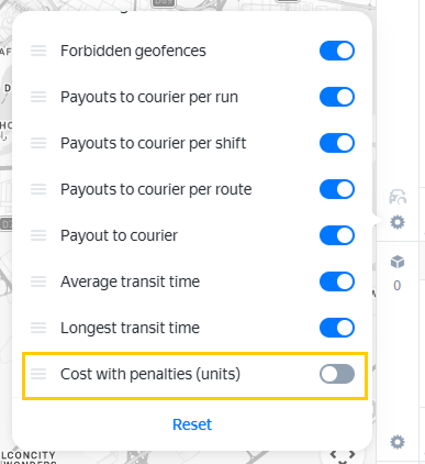
The column shows the cost for each route total_cost_with_penalty taking into account the penalties for this route. But the sum of these values across all routes may not match the metric total_cost_with_penalty for the overall solution, as it also takes into account penalties for violating routing options.
For example, the total cost of the solution includes penalties for unassigned orders or for the unevenness of routes relative to each other. You can view the total cost of the solution, including penalties, in the API response.
Editing a solution
You can change the planning result:
-
Exclude an order from the route
Drag the row from the Orders table to the Unassigned orders table.
-
Include an unassigned order in the route
- Tables: click the route in the table or on the map. Drag the row from the Unassigned orders table to the Orders table.
- Map: drag the unassigned order's map icon to the target route.
-
Assign a route to another vehicle
Highlight the vehicle in the Routes table and click Change vehicle. In the window that opens, choose the vehicle.
If the original and selected vehicle have the same number of shifts, the order sequence is saved. Otherwise, the sequence can be optimized with a warning: "Shifts are different, the route can be rearranged when replacing the vehicle".
You can't assign one vehicle instead of another if they're linked to different depots. For example, if the vehicles on the sheet Vehicles have different
depot_idvalues, or if the first vehicle has adepot_idand the second one has astarting_depot_id,middle_depot_id, orending_depot_id. For more information about linking vehicles to depots, see Start from one of multiple depots. -
Move an order from one route to another
Use:
- tables — drag an object from the Orders table to the Routes table in the row of the target route;
- map — drag the order point to the desired route.
To drag multiple items at once, select them first. To select multiple different rows, press and hold Ctrl. To select consecutive rows, press and hold Shift, then select the first and last row of the range you need.
After each edit, the summary indicators are recalculated. Metric changes are displayed in the Routes table. If an indicator has improved compared to the initial planning result, the difference is highlighted green. If it has degraded, it's highlighted red.
Every time the results change, a new task_id solution ID is generated. Save the page address so you can resume work on the edited version later. The original solution won't change, and you can still go back to it via its link.
Note
Your route is optimized for current traffic conditions, considering factors such as congestion and road closures. If you need to revisit this route later, we recommend planning it again rather than editing the existing one.
Solution link parameters
To highlight specific routes in a solution, you can specify parameter values when linking the solution:
https://yandex.com/courier/companies/<company_id>/depots/all/mvrp/<task_id>?<parameters and their values>
```.

You can specify one or more parameters, joining them with the `&` symbol. You can assign a specific value or an array of values to a parameter — the array elements are listed in the address bar, separated by `%2C` (which corresponds to a comma).

You can use the following parameters:

- `activeVehicle=<courier id>` — highlight a courier's routes;
- `hide=<courier id>` or `hide=<courier id array>` — hide a courier's or multiple couriers' routes;
- `hide=*` or `hide=all` — hide all routes;
- `hide=all&showHidden=<courier id>` or `hide=all&showHidden=<courier id array>` — hide all routes except for those belonging to the specified courier (couriers);
- `showPath=<courier id>` or `showPath=activeVehicle` — display a laid over roads route for the specified or highlighted courier (in this case, [laid over roads](#routes) routing needs to be enabled for the company).

**Example 1**

Hide routes for the courier whose `id` = 2:
https://yandex.com/courier/companies/<company_id>/depots/all/mvrp/<task_id>?hide=2
**Example 2**

Hide all routes except for those belonging to couriers 2 and 3:
https://yandex.com/courier/companies/<company_id>/depots/all/mvrp/<task_id>?hide=all&showHidden=2%2C3
**Example 3**

Highlight and display laid over roads route for courier 2:
https://yandex.com/courier/companies/<company_id>/depots/all/mvrp/<task_id>?activeVehicle=2&showPath=2
<!-- source: en/vrp/_includes/feedback.md -->
<a href="feedback">
  <span class="button">Contact support</span>
</a>

<style scoped>
.button {
  border: none;
  outline: none;
  display: table;
  text-align: center;
  text-decoration: none;
  cursor: pointer;
  font-size: 15px;
  font-family: var(--yc-text-body-font-family);
  padding: 12px 30px;
  border-radius: 10px;
  color: black;
  background-color: #ffdb4d;
  margin-top: 20px;
    }
.button:hover {
  box-shadow: 0 1px 3px rgba(0, 0, 0, 0.2);
  background: #ffd633;
}
.button:active {
  box-shadow: inset 0 1px 3px rgba(0, 0, 0, 0.2);
  text-shadow: 0 1px 3px rgba(0, 0, 0, 0.2);
  background: #ffd633;
}
.dc-mini-toc__section_active>.dc-mini-toc__section-link {
    border-left-color: #dd0000;
    color: #dd0000;
}
.dc-mini-toc__section>.dc-mini-toc__section-link {
   color: #4a7acf;
}
.dc-mini-toc__section-link:hover {
    color: #4a7acf;
}
</style>
<!-- endsource: en/vrp/_includes/feedback.md -->